Overview
A Web Map is where one designs the layout of the web map, styles the layers, provides labeling on the layers, transparency, set zoom levels, manipulate time intervals on time-enabled layers, and configure layer pop ups.
The Web Map viewer is where one spends a significant time creating the “web map” to then use for web map apps, dashboards, experience builders, and mobile apps such as Field Mapper and ArcGIS Explorer.
The organization of the “New” Map viewer is presented in other pages. Refer to those as needed.
Configuring Layers
Layer configuration occurs with changing color (outline and/or fill), line width, line type, transparency, filtering, in addition to labeling (if even needed)….remember, Web Maps are dynamic which means the map changes a different scales, so different kinds of point style sizes and layer visibility can be set to accommodate this changing (dynamic) environment.
Configuring the layer’s pop up is also part of styling. See this section for more details regarding changes with the pop up.
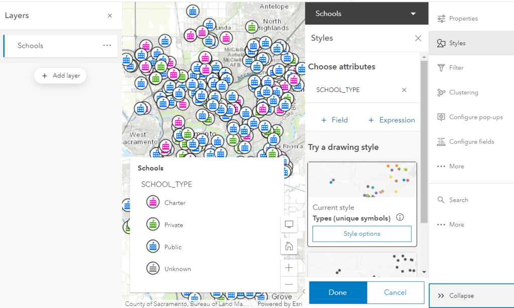
Depending on the type of data (point, line, polygon) different kinds of layer styles can be used. These can include single symbol, unique symbol based on an attribute, graduated symbols based on an attribute (such as area, size, population, count, etc), and color ramps–color gradients that often go from a low to high or high to low value. The gradient and color ramps can also be manipulated based on data distributions (e.g. equal quantities, normal, manual, etc).
The screenshot below shows the styling interface for a layer. NOTE: The various tools for styling and working with layers are shown expanded to see the tool name with the tool icon).
Try adding the “City of Sacramento Schools” (search for these key words in ArcGIS Online) and explore different options for styling and working with layers.
Styling
Provides the options to change colors, line widths, symbols (single or by unique symbols based on attribute values [+Field]), have the ability to choose point styles from various “symbol sets,” and adding Arcade expressions [+Expression], if needed. NOTE: These symbol sets are indexed or easily searchable. Basically, it comes down to working with the styles often and remembering “where” certain symbols live.
Style options – allow to change colors for unique styles, symbols, and transparency.
Saving Changes
Changes are made immediately. To save the changes permanently,
- Click Done to save the specific style changes
- Click Done again to save the changes to the layer and close the Styles window.
Try making different kinds of style changes for the schools layer to become familiar with where and how to make different kinds of changes.
References