What is Web GIS?
Typically (I think), when one is asked this question, thoughts can range from looking at static PDFs on a web page to interactive map applications that some of us have experienced while driving, hiking, ordering food, collecting data, experiencing various forms of social media. The range is pretty broad.
For this class, we will learn, work with (configure) various forms of map layers that GIS professionals (and some non-GIS professionals) that are familiar using the ESRI web platform ArcGIS Online (AGOL).
One can actually do quite a bit in AGOL (except for the analytical capability that exists on desktop GIS products….currently, ArcGIS Pro and not too long ago (ArcGIS Desktop…and many of us know this as ArcMap, ArcCatlaog, and ArcToolbox). You will find “analytical” tools in ArcGIS Online, but currently, it is a far cry from desktop GIS capabilities….think of some of the large magnitudes of data and computer processing needed to perform “spatial analysis!” I mention in the classes “Don’t go out and by an expensive computer!” The classes aren’t doing the routine heavy lifting of many organizations of “spatial data processing and analysis” not to mention the capability of making great looking (cough, static) maps.
My opinion, what us “GIS Nerds” do on desktop software will eventually be completely done in the “cloud” and will probably be sold to us as “GIS as a Service (GISaaS)” or “GIS as a platform”….blah, blah, blah. If you already “buy” any “Premium” service for your devices (TV, phone, tablet), you are using “Software as a Service” (SaaS), Platform as a Service (PaaS), Infrastructure as a Service (IaaS), etc, etc. For me I annually pay for Hulu, Prime, Gaia GPS, All Trails to name a few. AGOL is not too much different.
Speaking of “ESRI selling us stuff.” Web GIS (just as many “web services”) using a model called “service credits” to charge for storage, editing, and analytics when using the “ESRI Cloud” (i.e. AGOL). This is in addition to the annual charge of “user types” of per user per year. Some organizations have what is called an ELA (End user License Agreement) where an organization works with ESRI to determine the current and near future needs are (this can include desktop, web GIS, users types and number, and any additional service credits needed for any heavy duty or high occurrence needs (think routing and navigation, web-based analytics, and feature editing, and data storage (vector and raster).
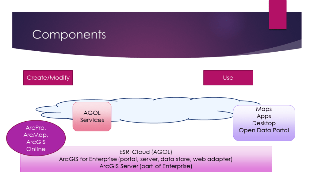
Components of Web GIS as far as ESRI is concerned
ESRI has developed a great Web GIS platform (ArcGIS Online and ArcGIS Enterprise) that didn’t exist 6-8 years ago. There was actually a “dead space” in the ESRI platform that couldn’t not (or was not competing very well with Google and a defunct platform GeoServer). GeoServer (rebranded a number of years ago as Boundless GIS) was bought by Planet.com and now only focuses on aerial and satellite image products and platforms.
Any who….ESRI got its product developers together and launched AGOL a few years ago…..and not too much later, GIS for Portal (now rebranded as ArcGIS Enterprise and does include other components) for on-premise (on-prem) Web GIS.
(Side note): The Web GIS class used to be taught with an “olllllld” ESRI platform called ArcIMS (Internet Map Server), and then ArcGIS Server. ESRI “did” do web GIS before Google was even a company, but there was a brief lull at ESRI.
The primary components of ESRI’s Web GIS Platform include:
ArcGIS Online (AGOL)
- The “ESRI Cloud.” Each organization (or even a paying individual) has a presence in the ESRI cloud.
- Create and Manage map layers (as web services/web layers). Map Layers show up in Content (i.e. the person who created it or the layers can be shared and put into groups so others can also edit and use in web maps. Given the right permissions, one can edit spatial features and attributes, data structure (aka schema), create views of data (this of this as the same data source, just different ways to present and share the same data).
- Cloud Data Storage. This can include map layers, rasters (often aerial, satellite, and/or UAV), photo attachments to layers (e.g. during field collection on feature layers). Storage can also include zipped sets of data to provide a common place for others to obtain data (if needed). With web map layers, other data formats may not be needed. Pro can interact with web layers and can be edited, if permissions have been granted. NOTE: Large data sets are likely undesirable for editing or even displaying. Some filters may be needed or operate on original data formats such as file geodatabase or enterprise SDE databases.
- Create, Manage, and use Web Maps. This includes layer styling, filtering, pop-up configuration, transparency, labeling (if really needed), incorporating time/date elements for viewing change over time, provided the data contains such elements.
- Administer and Manage Users, Permissions, Groups, Service Credit Usage, Software Capabilities. This is normally an administrative activity, so not all GIS staff perform this role. AGOL admins can change specific permissions and create custom roles for different groups or individuals. Depending on an organizations relationship with ESRI, AGOL admins can activate (or not) various kinds of software extensions and abilities, such as “collecting data (this is another options for ESRI to monetize its product line).
- Create and manage Web Apps. These come in the form of Web AppBuilder (WAB) viewing apps, editing apps, operations dashboards (Ops Dashboards), Field Mapper (data collection), Survey123, Experience Builder, there may be a few others that are not as common.
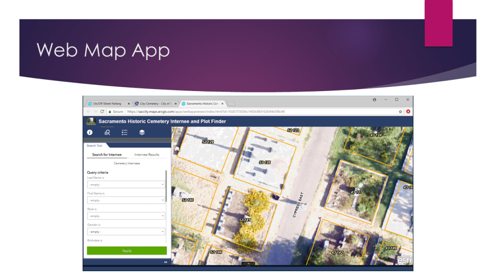
Web Maps
Web Maps is where all of the “web map making” takes place. Adding layers, changing styling, some filtering, transparency, labeling, zoom levels, pop up configuration and adding time/date capability that can be used in time-based widgets in web apps. Web Maps is the launch point to provide maps and layers to various kinds of Web Apps (viewers, editors, dashboards) or mobile apps such as Field Mapper.
Web Apps (Web AppBuilder – WAB)
Web Apps originate from Web Maps. They are “configured” with different templates, design layouts, and widgets. Depending on layer and web map permissions, Web Apps can be configured to have editing tools to create/manage spatial and/or attribute data. Dashboards are very popular for a single place to view map layers and metrics or aggregations of data values.
Experience Builder
Experience Builder came out Q3/4 of 2020. This option provides a different means of providing map and other characteristics in one place and can have multiple pages/tabs, etc. Widgets exist for Experience builder, but are not as developed as Web AppBuilder.
Story Maps
This is a part of the Web GIS platform that I describe as a “digital marketing” option. It’s pretty effective and more of a “presentation” platform that uses pre-existing maps and apps and written and media content together to tell “a story.” Think of creating a Power Point presentation…not much “GIS” to configure a presentation.
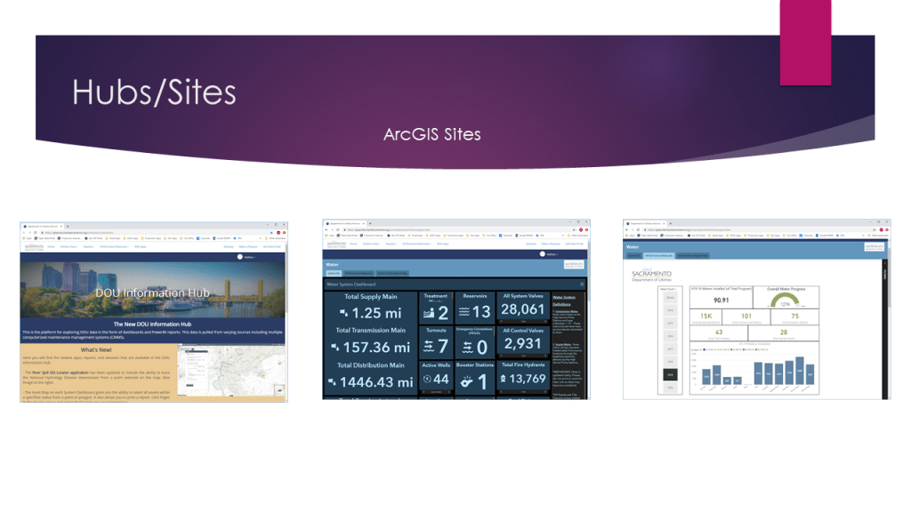
Hub Sites
Hub Sites preceded Experience Builder and can be used as a single place to present a variety of information, links, etc. Sites can be used for “campaigns” (think social services, homelessness, climate, conservation, politics, etc). Experience Builder seems to have a richer set of options that Sites and is fairly easy to configure, once the basics are learned.
ArcGIS Enterprise (On-premise Web GIS)
ArcGIS Enterprise (you may also hear AGOL on-prem, Enterprise, Portal for GIS, Portal, internal portal, among others). “Enterprise” is not just AGOL installed on an internal web server. It is a slightly different product than AGOL since it does not have 1:1 parity of functionality with AGOL and is about 6 mo – 1 yr behind functionality of AGOL. In addition to the same look and feel with web maps and apps, Enterprise also includes the back-end components of Web GIS (e.g. a data store – if data needs to be replicated to a single location for use on the web, ArcGIS “server” technology such as web adapters, security mechanisms for the server and possibly the network and user authentication.
Enterprise is Web GIS being served up and used by an organization. The organization comprises GIS staff who administer the platform and develop map layers, web maps, and apps for others to use. The non-GIS are typically “users” of the map layers, web maps, or web apps, but mostly use the web map apps. Select non-GIS staff can be given permissions to edit (either within an web app editor app or through a mobile collection app such as Field Mapper or Survey123). When map layers, maps, and apps are “shared to everyone,” this typically refers to all staff within an organization that has access through a corporate network.
Enterprise has become a rapidly adopted method of presenting and sharing spatial and non spatial data as visualizations (mostly web map apps, but some web maps) to an organization vs the traditional “static PDF.” Users or staff are often amazed at how much more rich an interactive web map experience is vs spreadsheets, charts, and graphs (although AGOL and Enterprise can do this through operations dashboards and experience builder). Also, if this doesn’t meet all of the needs an organization can use data visualizations tools such as Power BI.
Other Related Components
Other parts of the Web GIS experience is Pro (legacy, Desktop). Pro is likely going to be a software used to publish and overwrite (in some cases) web services that are published to ArcGIS Online or Enterprise.
Pro (and possibly Desktop) can/will be used to also “edit” data directly in the web service. Pro typically will be used by GIS professionals, so they have more tools than a non-GIS person to edit, publish, and overwrite.
Like I mentioned above, AGOL (or even Enterprise) can be used directly in many cases, but since we are mostly focused on the GIS Professional responsibilities, then Pro is part of the overall platform.
